
FISHING RULES AND REGULATIONS
All anglers 12 years and over must have a valid Environment Agency rod license. Allowing each angler up to two rods.
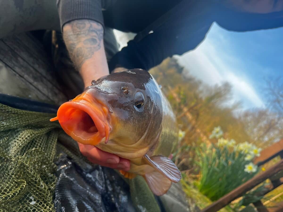
Barbless hooks ONLY - preferably a maximum size of 10
NO Bait restrictions.
Please, no Keep Nets
No fixed rigs
Fishing from allocated pegs only
Treat all fish with care
Minimum of 8lb line for Carp fishing
Do not leave your rods in the water unattended at any time
Do not carry fish back to the water. Use a net or sling
Unhooking nets must be used for specimen fish
Children under 16 must be accompanied by an adult
Boilies, particles, and ground bait are to be used in moderation
Float fishing preferred
A SHORT HISTORY OF THE AREA
The Old Gravel Pits lie in the Vale of York at the foot of the Yorkshire Wolds. After the last Ice Age, approximately 13,000 years ago, two glaciers, meeting and melting, formed a large lake. This lake was known as Lake Humber. Rich deposits of gravel, sand, clay and till were left behind as the glaciers retreated. The Old Gravel Pits lie on the shores of the former lake.
The River Humber was a major trade route throughout the centuries, and there is evidence of early settlement in the area. An extensive creek system existed in the early Iron Age between the Humber and towards Holme on Spalding Moor. In 1984, an early Iron Age log boat was discovered in the peat; this showed that goods were carried around the system from the Humber to the Vale of York.
The Parisi were the early inhabitants at this time and were possibly connected with the people of the “Arras Culture”. These were Iron Age dwellers of the Yorkshire Wolds, where remains of Cart Burials have been found. The Parisi was mentioned by Ptolemy (AD90 - 163)
The Romans used ports on the River Humber for trading. At Faxfleet, pottery has been found, suggesting that this was a busy trading port on the river system. The main Roman road from Brough to York follows the existing A1079 and may have followed the higher ground to avoid flooding. Many Roman remains have been found along the route.
The name of Pocklington is Anglian. “ton” is Anglian for farm or homestead; the name means the farm of Pocela’s people. The town was a leading settlement and is mentioned in the Doomsday Book as a Royal Manor. It developed as a marketing and processing centre for agricultural products. The earliest grant for a market was in 1245. The beck, which still runs through the centre of Pocklington, underneath the road, led to the establishment of water mills, which were used throughout the centuries for milling, the woollen industry, Tanning and Malting. Pocklington Church dates from Norman times and the main building, from between 1200 - 1450. Pocklington School was founded in 1514. The most famous pupil was William Wilberforce. Because Pocklington was always just off the main Roman road, the town changed slowly and is still reminiscent of earlier years.
The Domesday Book. The village is a conservation area and was a farming community until after the war. Allerthorpe Common was uncultivated with grazing rights until 1961, when the Forestry Commission acquired the land and planted softwoods. Around the 17th, 18th centuries, the Common was partly developed as a rabbit warren. Hemp pits were dug for rope making; these were filled in during the 1950s.
THE OLD GRAVEL PITS
The old gravel pits were originally agricultural land, the original farm name was Chicory Farm and the field name was Holmes. Strangely the field name Holmes can mean water meadow!
The site was opened for sand and gravel extraction in 1968, the gravel was used mainly in the construction of the York Bypass, and the quarry was finally closed in 1986.
We bought the gravel pits in 1988 and we have kept most of the land as it was then, with some landscaping at the entrance and down the drives to the cabins. The site is a refuge for many water birds and animals. The vegetation, which has gradually colonized the water edges, has made the whole area attractive and varied. The site will appeal to the nature lover, bird watcher, fisherman and those just wanting to get away from it all.
The main fishing lake (Digby Lake) contains Rudd, Tench, Bream, Roach, Eel, and Ide, and we have now moved carp into this lake. Pocklington Canal and Allerthorpe Common are within easy reach; both these areas have SSSI status (Sites of Special Scientific Interest). The Wolds Way and other Wolds walks are a short drive away for those wanting more energetic walking; the scenery on these walks is stunning. If a bird’s eye view of the area is wanted, then Pocklington Gliding Club will be only too pleased to transport you to the skies where you will be able to spot your lodge from the heights!
Agricultural land and good hedgerows surround the Gravel Pits. The hedgerow plants include Hawthorn, Blackthorn, Hazel, Dog Rose, Crab Apple, Guelder Rose, Dog Wood, and Elder with Ash as standard trees.
Although the site is still a “young site,” various habitats are developing well. It is becoming now more of a woodland site, than open grassland, we now have the problem do we allow the trees to mature, or do we start to selectively fall some, we are still deciding! There are two main lakes with several smaller islands and many inlets and spurs. Tree and shrub cover is mainly Willow, Birch, and Alder.
Magical moments captured by our guests!


